
New Rēzekne District Planning is applied and applied in practice
On the end of the previous year, we reported that the Rēzekne municipality council adopted the decision on the approval of the final version of the Rēzekne District Planning and Environmental Review on 1 October 2020 and the adoption of binding Regulation No 69 “Terms and conditions of the use and construction of the Rēzekne District Planning Territory and the graphical part” (Protocol No 25, § 1). In accordance with the laws and regulations, after the coming into force of the binding regulations and the publication of that decision in the Official Gazette Latvijas Vēstnesis, a period of 2 months was provided for both natural and legal persons for the appealing of the spatial plan. In addition to one month in legislation, the Ministry of Environmental Protection and Regional Development was provided for the provision of its assessment regarding the applications received and the compliance of the requirements laid down in the spatial plan with the laws and regulations. In the evaluation, the Ministry provided guidance and recommendations on the basis of which the municipality of Rezekne (hereinafter – the municipality) carried out corrections in the regulations on the utilisation and construction of the territory. On 15 February 2021, a statement by the Ministry was received that the new Rēzekne District Planning could be applied or “applied”. Consequently, since 15 February 2021 it can be safely said that a new local law is active in the area of land use and construction in the municipality of Rezekne.
What is the spatial plan and which is bound by it?
The spatial plan of the municipality of Rezekne (hereinafter - spatial plan) is a long-term planning document of the municipality, which means that it has been developed for a long period of time - up to a period of 12 years. The spatial plan of the local government affects many and different areas – environmental and nature protection, land use, business development, cultural monument protection, protection of valuable landscapes, infrastructure and other territorial development issues. In drawing up this programming document, the municipality has tried to balance the interests of all parties within the limits of its capabilities and competencies, taking into account the possibilities of development of the municipality. It is important to note that the spatial plan does not specify and duplicate requirements which have been discussed in another external regulatory act – in the law or Cabinet regulations (which have a higher legal force respectively).
The spatial plan is approved as binding regulations of the municipality and is therefore binding on any person (both legal and natural) who owns or is used and managed by a real estate in Rezekne municipality.
Composition of the spatial plan
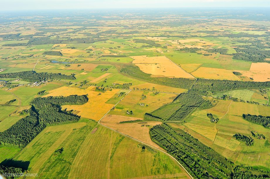
The spatial plan consists of two parts – the graphical parts (parish and village cards) and the regulations for the use and building of the part of the text (hereinafter – the building regulations). The graphic part shows the entire territory of the municipality of Rezekne - the borders of parish, villages and land properties, roads and streets, rivers and lakes, technical infrastructure (water drilling, purification facilities, power lines, etc.), flooding areas, bathing sites, public access to specially protected natural areas, as well as the authorised use of each plot of land, which is defined as functional zoning in legislation. In addition to the maps, all the protection zones identified in the legislation should be noted, which should be taken into account in the use and management of land property.
The provisions of the building, in turn, explain the illustration in the graphical part of the plan, namely laying down general requirements for the use and planning of fields and villages, explain the possibilities for use of property for areas which operate special conditions (such as landscaping areas), as well as determine specific requirements which may or may not be done for each parcel in the specified functional zone. In summary, the spatial plan defines the conditions for building and determines the possibilities for using any real estate.
Here are answers to individual questions, as well as valuable information about the changes envisaged by the new site plan
One of the most topical issues that were seen during the development of the spatial plan was the creation of new villages in the areas surrounding the city of Rezekne. The regulatory framework and the national setting are that the village status may be allocated to the part of the municipality where the concentrated building is or are planned, the people living permanently and the relevant infrastructure is established. In order to assess precisely which territories the village status is to be granted, a number of aspects have been assessed in the work group of the local government spatial plan, such as the current state of construction of existing land units, the business development forecasts, the provision of transport and engineering infrastructure, as well as other criteria and requirements of regulatory enactments. The municipality decided to pass on the public assessment (public consultation) a proposal on the establishment of village borders and village status for historical densely populated areas in the municipality of Rezekne, with a significant population where infrastructure development projects are already being implemented or planned.
In view of the absence of complaints from citizens during the public consultation of the spatial plan, four new villages have been established with the approval of the plan: Plexen village Ozolaine civil parish (historical cottage and horticultural cooperatives with the surrounding rural and wooded areas) and three villages Griškānu parish Luxurious village (~ 40 submissions from households have been received regarding the establishment of the village), the village of the village (combines historical village Once and a small part of Juvenovka, Littsman and Laughter for small villages and village young Chachi (combines Shell historical village with part of Wippings, Pocelujevkas and Splashes areas). When determining the status of the village, the local government will have greater opportunities to raise funds such as street and utility infrastructure
In accordance with Section 14, Paragraph 1 of the Administrative Territories and Territories Law, the names of the villages shall be granted and the villages shall be renamed by the council of the municipality. In accordance with the requirements of Sub-paragraph 24.1 of Regulation No. 50 of the Cabinet of Ministers of 10 January 2012. for local governments, before taking a decision to grant or change an official local name for a specific object of destination (populated site), there is an obligation to consult and receive the opinion of the national language centre. Initially, the proposal proposed by the municipality to the national language centre was to form village names from all small names, separated by dashes – village Juvenovka – Dreizi – Wiping and village Chachi – Poceluyevka – Showhotsk. The national language centre, in view of the fact that the names Jupatovka and Viping are currently also assigned to the parts of the city of Rezekne (neighborhoods) and their repetition (duplication) is not supported; the fact that the Rēzekne municipality has already existed in THE parish OF Silmalas, the Chachi, a loch Chachi and Trupu Chachi, in assessing the Latin origin, the good sound, the cultural historical origin and the other criteria, offered two options and suggested that the local government should make the names as follows: (1) the village created by the merger of the current Jupatovka and Dreizu villages: Big Dreizi or New Dreizi; 2) a village created by combining the current villages of Wiping, Chachu and Poceluyevka, Young Chachi or Pearls (since the village is located in Wiping Forest).
The municipality, in the light of the guidance of the national language centre, ruled in favour OF THE names of Griškānu parish villages “young Chachi” and “big Dreizi”. The local government's proposals regarding the names and borders of the village were transferred to the public assessment for public consultation, where no objection was received at the time of public consultation of the spatial plan regarding the creation of new villages or the names of the new villages.
With the establishment of new villages in the spatial plan, or the name of existing villages, the clarification of the village borders and the allocation of street names, the sorting of addressing issues has already been initiated and progressively continued. The requirements of Cabinet Regulation No. 698 “address regulations” shall be determined for the addressee of the claim. On the basis of paragraph 9 of these Regulations, which provides that: a local government council or a competent authority of a local government, without the consent of a person, shall have the right, when assessing the particular situation, to grant an address if the address for the object of the addressee is not granted, and to change, liquidate or specify the form of the address of the address if the registered address does not comply with the requirements referred to in these Regulations.
All decisions of the local government regarding the change of address shall be sent to the State Land Service address register (hereinafter - address register) for registration of changes. Information from the address register regarding topical addresses shall be transmitted electronically and automatically transferred to the State cadastre information system and the State single computerised Land Register. Which means that information regarding the change of real estate address (without ownership of real estate owners) is also entered in the cadastre register of the State Land Service and in the Land Register, without changing the other information regarding immovable property (including The number of the Land Register compartment, the name of the property, cadastre number, areas, owner, encumbrances, prohibited prohibitions and mortgages, etc.).
The updated information of the address register information system is later also received by all national registers and institutions which have concluded a cooperation agreement with the State Land Service (including the State Revenue Service, the Citizenship and Migration Affairs Office (maintains a population register, whose data is also used by the State Social Insurance Agency), rural support service, the State Plant Protection Service, VA “Agricultural Data Centre”, the State Agency for Employment, the Emergency Medical Service, the Nature Protection Administration, Latvian Post, etc.). The address is therefore automatically changed in the population register and persons do not need to redeclare their place of residence.
Residents should be informed of the change of address only by the authorities with whom legal relations are established (contracts concluded) and whose address change may be of interest, such as SIA “TET”, “Latvenergo”, banks and other companies. The change of address must also be communicated to persons with whom personal and applied correspondence is held so that the letter is guaranteed to reach its addressee. At the same time, it should be pointed out that credit institutions which, in favour of a pledged immovable property, which have changed their address at the initiative of a municipal council, do not have a legal basis to require that a credit agreement be amended as a result of the change in the address of the pledged immovable property, resulting in a change in the interest rates of the credit or otherwise increased expenses of the borrower. We call on citizens to be careful and willing to disagree with such amendments.
Cabinet Regulation No. 698 of Cabinet of Ministers Regulations No. 698, Paragraph 32 of the Regulations prescribes that: if the address has been changed, as well as if the form of the statement is specified, in accordance with the requirements referred to in these Regulations, the documents in which the previous address is used shall be valid and the change of documents shall not be performed except if it is provided for by a special regulatory enactment. In most cases, when the address is changed, the laws and regulations do not provide for mandatory change of ownership and other documents. Consequently, documents (e.g.: Land-book certificates, land border plans, contracts, vehicle registration certificates, etc.) issued until the change of address and where the previous address is registered are still valid. In addition, a cadastre number is indicated as the unique identifier of the property in Land Register certificates, which is not changed at the address change. If the document owner wishes, he or she may make a change or update thereof, but it is not mandatory and the local government shall not cover such expenses.
Note that in case of change of address, weapons owners and keepers (including hunters) must address the national police and submit applications for the issuance of a re-authorisation permit. A re-storage permit will be prepared on the basis of the submission in accordance with the new weapon storage site (address). The State fee of EUR 4,27 shall be paid for the re-authorisation. For more detailed information, please consult the National Police Officer by telephone 64603514.
How do business and economic operators act as an address change?
Legal persons (merchants) must inform the company register of the change of address by submitting a submission (form 18). The change of address in the Enterprise Register is free of charge if a reference to a local government decision regarding change of address is provided, or the address has changed due to changes in regulatory enactments. Additional information can be obtained by calling the business register advisory phone 67031703.
At the same time, we call on economic operators (taxpayers)) for which the place of performance of the economic activity or the address of the unit of the State Revenue Service (hereinafter - SRS) is registered in immovable property, to which the address has been changed, ON THE SRS website www.vid.gov.lv in the “Published database” section, or in its user profile, the electronic declaration system (EDS) verifies whether the address of the property in question has been changed. If the address is not changed, please inform the SRS. No additional costs related to the change of address IN THE updating OF THE SRS data shall be applied. Those merchants who use cash registers shall make appropriate changes to the cash register software and address the service service of the cash registers. For more detailed information, we invite you to turn TO THE SRS using THE EDS section “conversation with VID” and call the SRS Advisory phone. 67120000.
Information on the address of residence or property can be found in two registers. The current, legally valid property address can be found in the data publishing portal maintained by the State Land Service www.kadastrs.lvby entering the cadastre designation of the plot of land.
On the other hand, if the changed address is an individual's declared address, it is possible to ascertain whether the new address is also registered in the population register. latvija.lv in Portal using e-service “My data population register“. An extract of the immovable property belonging to himself or her from a Land Register with a changed address can be obtained free of charge at the portal latvija.lv
Once again, it should be stressed that the municipality, in the context of its capacity, addresses the issue of address issues and the decision-making on the change of address will be carried out gradually. Consequently, in those portals, the information will be updated only after a decision is taken by the local government and transmitted to the address register.
Criterion 1 — Authorised use of land property or functional zoning, which is determined for each unit of land in the spatial plan map of the spatial plan with a separate colour or index (designation).
| Village area | Rural area |
| In the village area there is a dense residential building and, above all, certain Mansion Building Territories (DzS and (1) and Agricultural areas with index L1.
In addition to the village areas at the request of the owners, it was also possible to predict and determine the functional zone Mixed centre building area (JC), which allows wide use of the area for various purposes (residential building, office building, construction of light industrial enterprises etc.). |
In most cases in rural areas Agricultural areas (L) and Forestry areas (M).
National legislation stipulates that: Mansion Buildings (DzS) and Mixed centre building (JC) territories outside the villages may not be determined by local governments. |
Criterion 2 — Sparting possibilities for parcels in villages are much wider
A more diverse distribution of property in the village area is a particularly important factor in building new residential houses, creating a dense, compact building and meeting demand for residential blocks or “sleeping areas” in the suburban area.
| Village area | Rural area |
|
In rural areas the minimum area which may be separated is 2 ha.
The laws and regulations prescribe only individual exceptions where an area of less than 2 ha may be separated (e.g. single separation from the rest of the territory etc.). |
Criterion 3 — real estate tax
The property tax (hereinafter – tax) is calculated by the local government from cadastral value of the immovable property determined by the State Land Service. As soon as the cadastral value of the property changes, the amount of THE tax also changes. On the other hand, the cadastral value is affected by the two main criteria: 1 st land use (the intended purpose of the municipality, where it is important whether it is an agricultural, forestry property, or the property is planned or is already actually used for residential, production or commercial construction) and the way in which construction works are used (whether the building is used for living, commercial or production, or it is defined as engineering); 2. Location of the property: in determining cadastral value it is essential whether the property is located in a suburban or village with good infrastructure, or it is located in a remote location without real demand of the property in the real estate market.
| Village area | Rural area |
| THE tax does not change until the use of the property in the existing volume/form is continued and the land distribution or resettlement of the borders is not planned.
If land property distribution or resettlement of borders in building territories (DzS, DzS1, JC etc.) is carried out and where the land use is currently determined by agricultural land, THE tax may increasebecause in the process of dividing the plot, the municipality specifies the purpose of the use of the property for both the remaining and the new plot of land. According to the building area specified in the spatial plan, the purpose of the use of immovable property will be changed from the land used in agriculture to the building land or not to acquire the building land. Each case in the local government is assessed separately, according to the personal submission/suggestion received. |
THE tax does not change if the use of the property is continued and the land distribution or resettlement of the borders is not planned.
If the distribution of land property or rearranging of borders is carried out, the purpose of the use of real estate may be changed/clarified and the changes in THE tax may also be possible. Each case in the local government shall be evaluated separately, according to the submission or suggestion received by the private person. |
Criterion 4 — Requirements for construction the building regulations of the spatial plan, as well as external regulatory enactments in the field of construction and property use are laid down. One of the most important parameters is the density of the building which determines the extent to which the total area of the plot may be built.
| Village area | Rural area |
| 30 % of the total area of the parcel may be built in the village area Mansion in residential areas (DzS and DzS1) and Agricultural area (L1) or 40 % of the total area of the plot Mixed centre building area (JC). | May be built up to 30 % of the total area of the plot Agricultural area (L) and 5 % Forestry area (L). |
Criterion 5 — restrictions on the use of property under the requirements of the protection zone law
The protection zones are defined in regulatory enactments, which are intended to protect objects of different kinds (both natural and artificial) from undesirable external effects, ensure their exploitation and safety, or protect the environment and the person from the harmful effects of an object. The width of the protection zones is laid down in the law of the protection zones and the individual objects are defined differently, depending on whether the land is located in a village or rural area. The Protected Bar Law also defines what may or may not be done in each protection zone.
| Village area | Rural area |
| In the village area, smaller areas of protection zones have been identified for several sites, thus increasing the area of property which may be fully exploited without restrictions imposed by the protection zone.
Examples of the width of certain objects in the villages:
|
In rural areas, the protection zones of individual objects are higher than in villages, such as:
|
Criterion 6 — Requirements for the accounting of individual sewerage systems
Since mid-2017, there is a regulatory act in place in the country (CABINET Regulation No. 384 “Regulations on the management and registration of decentralised sewerage systems”), which prescribes requirements for the management and registration of decentralised sewerage systems. These Regulations apply to waste water sewage systems which have not been added to centralised sewerage, so to both local sewerage systems installed in a residential house or cottage, and a single-seat installed storehouse or “small household”. The purpose of the regulations is to reduce environmental pollution and illegal discharge of waste water into ditches or waters, reduce threats to human health, arrange and facilitate the emptying and exportation of sewerage systems. According to the The Law No. 19 of the municipality of Rezekne of 18 October 2018 “on the procedures for the provision and accounting of decentralised sewerage services in the municipality of Rezekne”, these requirements are binding on all owners or possessors of the immovable property, the immovable properties of which are located in the territory of the villages for which the borders are marked in the spatial plan of the local government.
| Village area | Rural area |
| As a result of the creation of new villages (Greychans, the great Dreizi, the new Chachi and the Pleikšņu village), the graphic part of the spatial plan highlights the boundaries of the new villages, so that: the procedures for providing and accounting for decentralised sewerage services will also be applied to these new villages. | In rural areas located outside the village borders, the procedures for the provision and accounting of decentralised sewerage services shall not be applied. |
The previous Rēzekne District Planning in the areas of summer and horticultural cooperatives, most often historically formed in the vicinity of the city of Rezekne (Jupatovka, Litavnieki, Piebalgs, large Garanchi, etc.), Kaunatas parish at Razna Lake (Vilkakrogs) and elsewhere, provided that these areas may be built up to a maximum of 10 % of the total area of the plot. The building regulations also provided for the possibility of building only single-floor buildings with a maximum height of 7 m. These requirements often prevented landowners from legalising their previously built residential buildings and structures, so that ownership and property management were also hampered.
In view of the fact that more than 40 private submissions were received, the municipality decided to make changes to the building parameters. Since the entry into force of the new spatial plan, the construction areas of the cottages and garden houses (which in the new plan for villages are defined as Mansion building area with index DSS1) is permitted to build 30 % of the total area of the plot of land, the permitted number of buildings and structures of structures is determined up to 3 floors and the maximum building height – 9 m. The areas of cottages and garden houses located in rural areas outside the villages are subject to: Agricultural area (L) the specified design parameters, respectively, where the building density is 30 %, the maximum number of floors – up to 3 and the maximum building height – 12 metres. Further notes that the assessment of the construction intention also takes into account a number of other criteria, such as distances to the boundaries of the neighborhood parcel, insolation (sun-generated room lighting), fire safety conditions etc.
During the development of the spatial plan, extensive work on the updating of the cartographic material took place:
- in cooperation with the Latvian Geospatial Information Agency and the State Language Centre, the names of border villages and cemeteries have been adjusted;
- specified municipal roads (incl. deleted road sections);
- a total of 52 villages (including, according to the current situation, the existing 48 village boundaries, where the most significant changes have been affected BY villages Dricāni, Ratnieki, Ilzeskalns, Malta, Ciskiren, Stoļerova, Rosica, Prezma, etc.);
- according to the current NSAI “Latvian State Roads” information, the spatial plan illustrates the planned route of the Rēzekne City Southern border (State main road A15 connection to A12) route corridor, which is in the territory OF Ozolaines and Griškānu parish. Until the detailed construction plans of the motorways are being developed and the area necessary for the construction of the roadway is determined precisely, any new construction intention in the land properties of the route corridor shall be co-ordinated with THE VAS “Latvian State Roads” and the construction board of the local government;
- having regard to economic considerations, access opportunities and other factors, in small stages, the cross-border between THE parish OF Maltas and Lūznavas as well AS THE parish OF Ozolaines and Griškānu;
- the National Protection Areas (hereinafter referred TO AS “IA”) 40 national protected cultural monuments (separate churches, cultural historical mud parks and structures Audriņu, Bērzgales, Gaigalavas, Lūznavas, Maltas, Ozolmuižas, Rikavas etc.) have been developed and approved in the National Cultural Heritage Administration. In view of the fact that the protection zone of the protection zones around national protected cultural monuments in rural areas is not less than 500 m, the areas OF IA are determined according to a specific situation in nature, where they are often even 10 times smaller after the change. Reduction of the protection zones in the most direct way has been exempted from the bureaucratic burden and restrictions on use for a number of land properties located in the vicinity of cultural monuments;
- the requirements of the Land Management Law and the spatial plan of the spatial plan are displayed on access to inland public waters (Raznas, Gaides, Feimaņu etc. lakes) and specially protected natural areas (Razna National Park, Nature Park “Aamovas lake” etc.). Access points are established in villages and rural areas with the aim of ensuring access to recreational and bathing areas of pedestrians and cyclists. In most cases they are determined by the municipality/country estate area. In places where access is provided for a land property belonging to a private person, it is determined as a restriction of the right of immovable property in favour of the company and the owner of the land is entitled to compensation for losses caused by the determination of the restriction.
If the owner wishes to split his land estate in two (or more) parts and the property is not built at that time
| Condition | Exceptions allowed |
| May separate/divide and create new parcels where each of them is not less than 2 ha. | A minimum area of 2 ha is not observed in cases where the land parcel is separated by engineering structures (for maintenance or construction thereof) when the detachable parcel is necessary for the construction and management of objects of a public nature, production, public or commercial nature, as well as in cases where rearranging the borders of adjacent land units or merging of several smaller parcels into one unit of land is carried out. |
If the owner wishes to divide the land property located in the territory of his or her rural territory (the residential house is located on the property, etc.) in two or more parts
| Condition | Exceptions allowed |
| May separate/divide and create new parcels where each of them is not less than 2 ha. | A minimum area of 2 ha is not observed in cases where an existing single area is separated from the rest of the land. In situations where separate structures need to be separated, or the built-in land unit is a joint property, or if the land and structure have different owners, the division of the plot of land may also be performed by indicating the areas necessary for the management of the actual structures. |
If the owner wishes to separate the land estate located in the territory of the village the minimum areas of newly constructed parcels shall be determined separately in each functional zone where: Mansion in the building area (DzS) – 1200 m2; Mansion in the building area (DzS1) 600 m2 and Agricultural area (L1) – 2500 m2 . Mixed centre building area (JC) it is possible to divide the land units according to the intention indicated by the owner, as the minimum areas of the newly built land units are not specified in this zone.
What can be built?
The requirements for building and building parameters for each functional zone shall be determined in the regulations on the construction of the spatial plan, in parallel with the requirements of other regulatory enactments (laws and Cabinet regulations) in the field of construction.
Can a land unit be built in a rural area less than 2 ha?
May, as on land units less than 2 ha, the building parameters and the conditions of use of the territory referred to in the construction regulations of the spatial plan and the conditions of utilisation of the territory, as well as the conditions for the land units which are larger than 2 ha shall be valid.
There is one single-seat building on the parcel. Can a second residential building be built on the same plot of land?
In addition to external regulatory enactments, the spatial plan shall not restrict the number of residential buildings in the single-seat, so one or more residential houses may be built on the plot of land, taking into account the building parameters referred to in the building regulations, including the building density indicators. The density of the building determines how MUCH % from the land unit may be built which, depending on the zone, is most often within the range of 30-40%.
The local government draws attention to the fact that in the future, if the land owner wishes to perform the separation of these residential houses, the distribution of the plot of land will be much more complex and possible only in the cases specified in the laws and regulations. Changes in legislation can also not be predicted by the local government, so the owner must consider such a decision.
Voluminous involvement of society in the development of spatial plan
During the development of the spatial plan, in accordance with the requirements of regulatory enactments and the additional initiative of the local government, various measures of public involvement were ensured. Citizens, starting with the start of the planning process in 2017, were invited repeatedly to provide both written and oral proposals and to participate and express their views on the public consultation of the spatial plan. Notifications and current information regarding the progress of the development of the spatial plan, planned public consultations and consultations were placed not only on the municipal website, in parish administrations on informative stands, newspapers (“Rezekne Ambassador”, “Panorama Rezekne” and in the informative newspaper “Rezekne municipality news”), but also in social media portals (www.lsml.lv, www.rezekneszinas.lv, www.lpr.gov.lv etc.) and radio messages. The most active involvement of the society was in the period from 14.02.2020 to 09.12.2020, when three (3) public consultations and nine (9) meetings with citizens and entrepreneurs were organised. More than 150 individuals were used to make their proposals.
Where to get information?
Site Planning Materials can be found on both the local government website www.rezeknesnovads.lv section for Citizens – Development and Planning – Rēzekne District Planning in 2020 and Latvian Geospatial Information Portal GeoLatvija.lv.
Rezekne District Municipalities The Head of the Development Planning Unit Anna Jaudzema calls on the people not to fear and with questions regarding both the possibilities of use, distribution or building of the relevant land, and the change of address and other proposals, to apply to the local government. In life, situations and owners' suggestions are very different, but the local government always, when assessing all the solutions laid down in regulatory enactments, seeks to take the decision to accept a decision with maximum benefit for residents, entrepreneurs or owners of real estate.
The information was prepared and compiled
Rezekne District Municipalities
Development Planning Division Territorial Planner
League Romanchuk